Saturday, May 13, 2017

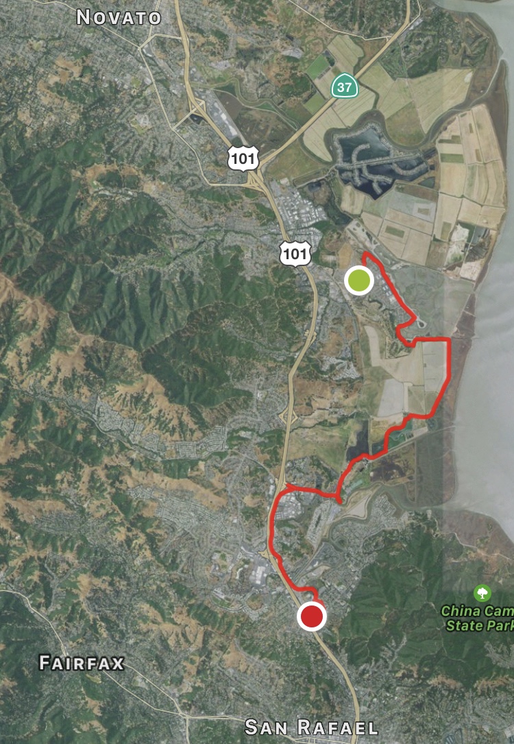
Day 18: Novato to Northern San Rafael


Day 18:  Novato to Northern San Rafael
May 12th, 2017

10.47 miles in 4 hours 27 minutes


After Monday's hike from Petaluma to Novato, I drove to Oregon to pick up my middle son Ben from his sophomore year in college.  We drove back through Sisters Oregon so I could get another cap from the Sisters Bunkhouse.  I had lost the previous one in the first week of this hike.  

I have been to Sisters a few times, the first time staying at the KOA outside of town on a bike trip from Vandenberg AFB to Missoula Montana.  We camped an extra night in Sisters to recuperate, and I had the chance to explore the town like a summer tourist.  I guess that's why it sticks more in my mind than most towns on that trip.  But that's another story...


Middle son and I on the trail

Instead of driving all the way home from Sun River where we spent the first night, we stayed at a Motel 6 in San Rafael, and Ben went hiking with me today.  We started out near the Air Force's former Hamilton Field, which is a recently constructed section of the Bay Trail, complete with a flood wall that separates the hiking path from the biking path.  I suppose this will be mandatory for every section of the Bay Trail in the future.

Flood wall in front of homes built on Hamilton AFB

Walking with another person was a different experience, and I'm grateful my son agreed to experience a day on the trail.  I think he liked the nature part of it, and wasn't as excited as me to see the new Marin County version of Caltrain slide by through the marsh. 


Appreciating Nature's Design

We ended at the Marin County Civic Center, for which pictures will have to wait until tomorrow.  This is a civic building designed by but not built in Frank Lloyd Wright's lifetime.

Cormorant in pond by Marin County Civic Center

We made one more stop on the way home, catching my youngest son Adam playing JV baseball for Sequoia High in Pacifica.  The sweat from the trail combined with the wind in Pacifica left me quite chilled by the end of the day, which required a warm shower.  It is always nice to be home.


Day 18:  Novato to Northern San Rafael


Accounting: 

    Starting Balance                                       70.03
  • Motel 6 in San Rafael.                                117.99
  • Sandwiches, Apples, Strawberries, and Moz. Cheese.     22.95
  • Uber ride back to Novato                               18.75
    Ending Balance                                        229.72


Kombucha of the Day -- Root Beer again


Voice Notes:


It would be amazing to be in one of these houses where their second floor back windows just stare off across the whole bay.

I really like how they regulate development in Marin. Wide open areas are preserved, and developments are tucked against a hill.


Farther on in the day is when I kind of crawl down in myself and rest there while finishing the walk.

Tuesday, May 9, 2017

Day 17: Petaluma to Novato


Day 17:  Petaluma to Novato
May 8th, 2017

10.01 miles in 4 hours 28 minutes


Made it back to 101 today, and off the dreaded CA 37. I would not recommend anyone else hike this entire section of the planned Bay Trail until things change. Legally I think it is ok, because it is a highway, not a freeway. But the bridge over the Petaluma river doesn't take pedestrians or even cyclists into consideration. There was a yard wide curb to walk on next to a yard high concrete railing. Walking on the roadway wasn't an option, as the two lanes of traffic were relentlessly using that space. I quickly learned to kneel down and hug the railing whenever a semi truck went by. It took courage each time I stood back up and took further steps along the bridge. I'm grateful for having made it across.


I feel like I've rounded the corner and I'm on the homestretch now, only a few miles down 101 back home. But first I have to go to pick up my middle son Ben from college in Oregon. We are planning to hike the next segment on the way back home on Friday. I made it to a hillside that once held a reservoir for the Hamilton Air Force Base nestled below it.

To get to Oregon, I got to drive back across CA 37 to reach I 80. That was part of what convinced me not to recommend hiking this section the way I did. When the cars fly over the hill on the western side of the Petaluma River, there is zero expectation of a hiker on the bridge blocking the beautiful scenery. While I was freaking out I was freaking others out. I'm glad I didn't know this before I started. I'm glad no one honked.


Day 17:  Petaluma to Novato


Accounting: 

    Starting Balance                                      120.54
  • Uber earnings to Novato                               (50.51)
    Ending Balance                                         70.03


Kombucha of the Day -- Root Beer


Voice Notes:


This Port Sonoma marina is the most desolate place I've been to on the trip.

That is not quite true, further down the road was a seemingly running marina.

Just saw a mama duck and her brood paddling down a little canal between the road and a railroad. When I turned and took an interest in them and reached for my phone she quacked out an order and they took off in a sprint of almost flying down the creek.


Hard to imagine a more awesome invention then the one I'm walking through where photosynthesis driven organisms produce pollen pollen on flowers and little hovering drone the machines pick it up out of the beautiful display and make honey.

Monday, May 8, 2017

Week 4: Richmond to Petaluma


Week 4: Richmond to Petaluma
May 1st, 2nd, 4th and 5th, 2017

51 miles (183 Total)
23 hours and 23 minutes (96 hours 11 minutes Total)

I ended this week by traversing the northern end of the bay up to the Petaluma River.  That day I had crossed the Sonoma River by Sears Point.  The day before I crossed the  Napa River to Mare Island in the evening and crossed the Carquinez Strait in the morning. The Carquinez Strait is fed fresh water by the confluence of the Sacramento and San Joaquin rivers in the delta upstream of the strait.  Everything is green and full of water around the bay.

I have to hike over the CA 37 bridge over the Petaluma River to get on with this hike on Monday morning.  And I can't start that hike until this blogpost is finished (I might add photos later).


Accounting: 

    Starting Balance                                       120.54
  • Uber Earnings over the weekend                         (32.15)
    Ending Balance                                          88.39

Kombucha of the Weekend -- fermented Margarita Mix

Voice Notes:

nada

Sunday, May 7, 2017

Day 16: Vallejo to Petaluma


Day 16:  Vallejo to Petaluma
May 5th, 2017

15.81 miles in 6 hours 40 minutes

Walking down CA 37 from Vallejo to the Petaluma River wouldn't be that different than walking across the San Mateo Bridge -- almost the same amount of traffic, and almost the same complete lack of crossroads, driveways, or even a place for an Uber driver to make a U-turn if I was to get picked up.


I had planned on walking only the 10 miles from the Mare Island onramp onto CA 37 to the intersection with CA 121 at Sears Point.  As I got closer to that intersection more and more people started honking encouragement at me, because they knew how far I must have walked down the highway.  


But at that 3 way traffic light there was no place for any Uber driver to pull over.  There is not even a crosswalk at that light.  So I had to push on another 6 miles to the first exit of any kind at the Petaluma Marina.  I had to run/walk the last 3 miles because I had a phone interview scheduled and it wasn't going to go well with all the trucks whizzing by.

My conclusion is, if you have the time, take the scenic route thru Napa and Sonoma on CA 121.  You get to traverse the ridge between the two valley towns, and that ridge was looking beautiful from the bay, with a combination of green and gold surfaces.  

The Ridge between Sonoma and Napa Viewed From the Bay

I can confess that this traversal on foot from Napa to Sonoma is possible, because in 2013 that was my last leg of a 12 person 200 mile relay I was part of, the Ragnar Napa race.  I was recruited by my niece Erin for this race, who was living in California at the time.  Part of the motivation for doing this hike is conditioning for the next Ragnar race I'm involved in, the 8 person 120 mile Ragnar Trail Northwoods, that by "coincidence" is near where she now resides in Wisconsin.

After making it to the Petaluma River, I quickly caught an Uber to the Larkspur Ferry Landing.  Thursday I came to Vallejo on the Vallejo Ferry.  By Friday I had crossed the northern end of the bay, and I was ready to take a different ferry home.

San Francisco Skyline from the Larkspur Ferry


Day 16:  Vallejo to Petaluma


Accounting: 

    Starting Balance                                       50.11
  • Uber to Breakfast                                       6.25
  • Uber to Mare Island starting point                     10.79
  • Uber from Petaluma Marina to Larkspur Ferry plus tip   33.59
  • Larskpur Ferry to San Francisco with Clipper Card.      7.25
  • BART to Millbrae                                        6.75
  • Caltrain to Sequoia Station                             3.75
  • SamTrans ECR to San Carlos Station                      2.05
    Ending Balance                                        120.54


Kombucha of the Day -- Pineapple again


Voice Notes:

You could say the United States is a Lutheran idea. Let me explain.

Luther did a good job of bootstrapping a decentralization of the Christian church.

The Declaration of Independence did a good job of declaring the sometimes necessity of decentralization in mankind's affairs

The constitution reinforced this decentralization (while binding them together into a single entity)

Seems to me like a connection between the 95 things nailed to the church door and the next amendment to the constitution.

Something to allow the people to govern themselves without the intervention of global capital.

The ridge between Napa and Sonoma is very picturesque.

I see. A point is where the hills actually have a chance to coming down to meet the water of the bay without all that marsh.

I have to admit that electricity distribution is far more peaceful than oil distribution.

The trail because of where it's positioned allows you to see the bay and it's surrounding hills 101 or 80 or 580 or 80 don't accomplish that because they're too close to the hills.

Zero out of 100 Uber cars

I'm getting honks of encouragement as I get closer to 121.

I see you approach to San Francisco (??)


Friday, May 5, 2017

Day 15: Rodeo to Vallejo


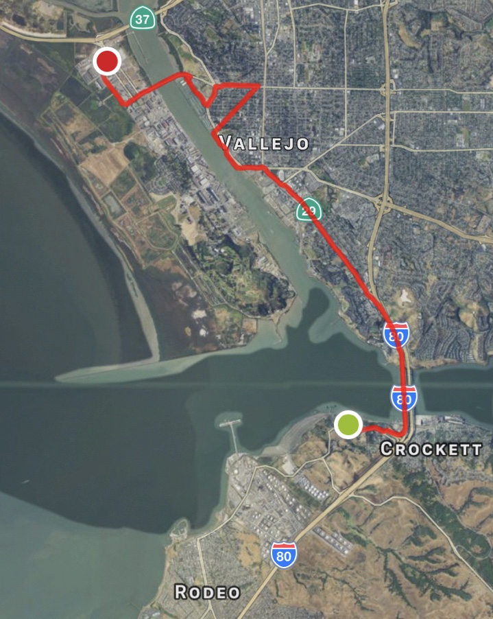
Day 15:  Rodeo To Vallejo
May 4th, 2017

10.6 miles in 5 hours 0 minutes

Most of the day's story can be read from the accounting of variable expenses below.  As you can tell I'm overlooking any "fixed" expenses (like new hiking shoes).  I'm just watching the money flow.  

And I'm also looking at it upside down.  It really isn't a balance, but a total outflow of cash for this trek -- which peaked today when I took SamTrans to Caltrain to BART to the Vallejo Ferry to Vallejo, and then stayed the night in Vallejo.


Waiting for the 5:39 Caltrain in San Carlos

Departing the San Francisco Ferry Building on the Way to Vallejo


I was always planning an overnight stay at the north end of the bay.  I realized today was the day when I ended the previous day within striking distance of the Vallejo Ferry terminal.

Vallejo Ferry Terminal

And it would give me an early start the next morning on traversing CA 37 (starting on Mare Island) across the north end of the bay, a ten mile trek along a highway shoulder far away from civilization the whole time.


Mare Island Naval Complex


More pictures will be forthcoming for my exciting trek on public transportation (oh and over the Carquinez Bridge as well).  But I botched getting both my computer and my phone on the same WiFi last night, and uploading a day of pictures over this cafe's WiFi just isn't happening.  And the highway beckons...


The Carquinez and its Shadow Bridge

Day 15:  Rodeo to Vallejo


Accounting: 

    Starting Balance                                     (110.00)
  • Uber Earnings on day off                              (27.25)
  • Bridge Tolls to date                                   24.00
  • SamTrans ECR to San Carlos Station                      2.05
  • Caltrain to Millbrae                                    3.75
  • BART to Embarcadero                                     4.65
  • Vallejo Ferry to Vallejo                               10.40
  • Uber to Rodeo                                          15.58
  • Uber back from Mare Island to Vallejo                   6.93
  • Vallejo Travellodge                                    89.00
  • Frymation Dinner                                       20.00
  • Characters Saloon O'Douls                               6.00
  • Coffees                                                 5.00
    Ending Balance                                         50.11


Kombucha of the Day -- Root Beer


Voice Notes:

The speed of this catamaran cruising out of the terminal is amazing.

The refineries occupy some of the best future parkland of the San Francisco Bay area.

The new Carquinez Strait bridge seems to be what brought this really nice part of the bay trail into existence.

Holding up a single finger when you want to ask a question of a person who's otherwise engaged is the universal signal? Seems sort of ambiguous. 

Vallejo seems like Lake City on Lake Pepin to me.

I like each Instagram post, either mine or others, to have a bubble of creativity, a wry slice of something interesting.

HTTP://circlebay.blogspot.com return

Not that bad a dictation of the URL.  I only had to remove a space.


Vallejo could be a seriously cool place.

Thursday, May 4, 2017

Day 14: Pinole to Rodeo


Day 14:  Pinole to Rodeo
May 2nd, 2017

10.86 miles in 5 hours 42 minutes

Got my haircut on the trail today, at "Yen Can Cut" in Pinole.  Yen did a great job of trimming while leaving some length, a good compromise given what hair I have. 


Haircut by Yen Can Cut

And then I spent a large chunk of the day hiking through the "Phillips 66" Refinery just south of the Carquinez Bridge.  This trek felt very much like slipping through Mordor, especially with what look like very new signs on every fence telling me the feds are providing security for these established fossil fuel interests.


San Francisco Refinery in Rodeo

Private Property protected by New Signs


Southbound Amtrak Capital Corridor Train
The other established interest in the area is the railroad, Burlington Northern Santa Fe (BNSF).  Long ago they grabbed all of the shoreline in this stretch, as a necessary route around the hills of Richmond to get to Sacramento from Oakland.  Though the line is still owned by BNSF, it is mostly used for a regularly scheduled Amtrak train to Sacramento.  Compared to Caltrain it is a very scenic ride down the coast I want to catch again.


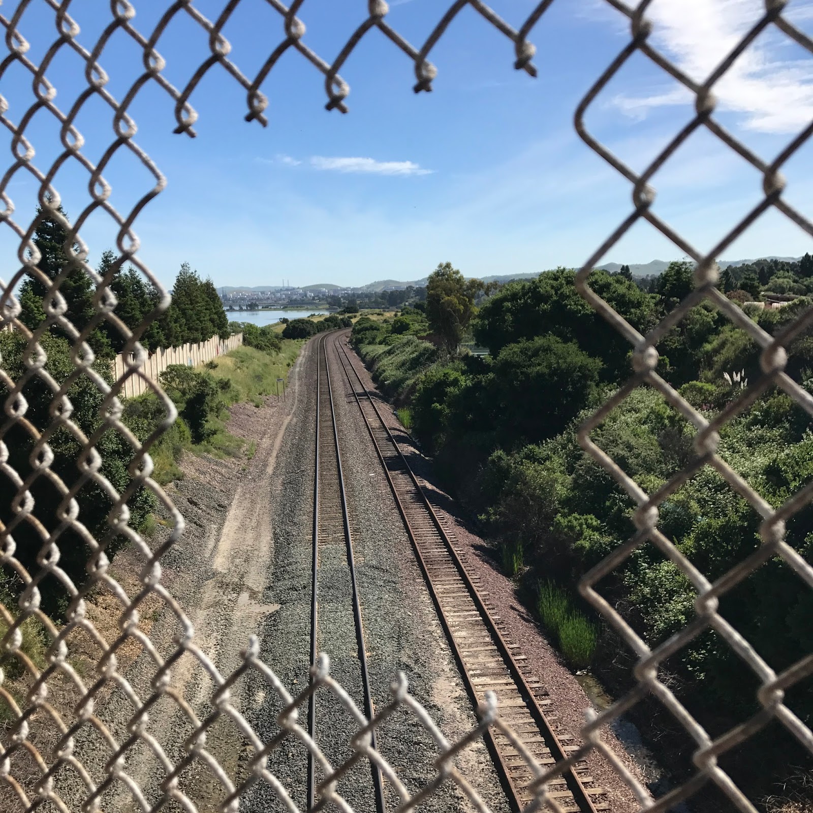
BNSF Tracks along the Bay

Hole Carefully Inserted for Photo Opportunities
As you can see below, almost every other day I goof up using the MapMyRide app, failing to end or start the walk on time.  This day I thought I had ended it, and was surprised to find  on the train this morning that that had not happened, so the app adds one more waypoint to the walk, a waypoint that doesn't make much sense given the elapsed miles and time.


Day 14:  Pinole to Rodeo


Accounting: 

    Starting Balance                                      (86.30)
  • Uber Earnings to Pinole.                              (30.49)
  • Bearclaw from Bearclaw Bakery (plus drink)              4.50
  • Uber back to Pinole                                    12.72
  • Smart Stop in Pinole                                    3.99
  • Uber Earnings from Pinole                             (14.42)
    Ending Balance                                       (110.00)


Kombucha of the Day -- Pineapple!


Voice Notes:


This part of the trail is very good about maintaining a gravel path next to the paved one.

False start today because I walked the Bay Trail to a dead end maintained by the railroad company.

Historically must've been the railroad that was the first construction to drastically alter the bay’s shoreline and it's estuaries.

But oddly enough it's also the railroads and their abandoned yards that have preserved some of the most significant open space in the bay at least at sea level.

Using nylon mesh to stabilize a newly planted wild hillside seems a crime against the environment committed by the petrochemical industry.

After you sit down and cool off in the shade for lunch taking socks and shoes off I feel like a little reservoir or oasis of cool for the moment when I start walking again.

Walking through this San Francisco refinery feels like hiking through Mordor.

In the land of gas guzzlers anybody not using internal combustion is suspect.


Tuesday, May 2, 2017

Day 13: North Richmond to Pinole


Day 13:  North Richmond to Pinole
May 1st, 2017

14.01 miles in 6 hours 1 minute

This day made me think of stops and starts, how that happens on any path, whether hiking this trail or traversing a career.  In the book Good To Great, Jim Collins talks about successful organizations needing to maintain momentum in a particular direction to ensure sustained progress.  But what if the direction doesn't change, and the momentum can be stored in a battery for future use after a period of renovation?

That attitude of balancing recovery against exertion, repeatedly, is valuable to me.  I'm not lazy.  I'm not a workaholic. I'm both.

The Bay Trail stops and starts along this segment.  The trail around Pinole Point was beautiful, with a mile long hike on a beach where I found gold.  But before and after Pinole Point there were reasons why the trail can't yet go through.  Perhaps BSNF could rededicate its NPR advertising funds to helping solve this, at the place where its tracks enjoy this beautiful bay view.
Pinole Point Fishing Pier

And driving for Uber to and from the trail (setting a destination to match against riders) is a start and stop activity.  I cruise the rightmost lane ready to jump off the freeway and do some driver errand, like delivering a pizza to a hungry student in Berkeley.  But then I get back on the freeway, cruising in the rightmost lane, ready for the next bong on the app if it ever comes.

When I couldn't get to the trail near Pinole, I found myself walking thru a housing development that completely matched the California developer sub-division I grew up in in Minnesota.  They had the same simple ranch house style of 60 years ago.  


1950's-Era California Style Ranch House 

It's pretty likely not a single house is still in the hands of the original owner (not true in my Dad's case).  These houses have had their own stops and starts, with each new owner remaking them in their image.  One particular house had spiked steel gates and fences surrounding his property, an antique cannon facing the sidewalk, and two 50 foot tall flagpoles.  I wonder what the next owner of that property will do with that.  Things change, but which way?


Day 13:  North Richmond to Pinole


Accounting: 

    Starting Balance                                      (68.81)
  • Uber Earnings to Richmond                             (22.81)
  • Food Truck Coffee and Egg Sausage Muffin                5.00
  • A&W Root Beer                                           3.17
  • Fruit Agua while delivering                             3.00
  • Uber Delivery in Oakland                               (5.85)
    Ending Balance                                        (86.30)


Kombucha of the Day -- Passion Fruit and Tonic


Voice Notes:


I have this feeling Richmond will be the new Oakland as Oakland was the new San Francisco.

I did so well networking on the drive here for Uber that I left my computer in the car this time.

Ferries from Richmond and Redwood City makes so much sense as a way to alleviate traffic and a good alternative for telecommuting or computing while commuting. 

When the bridges and freeways are clogged at rush-hour who can get you there faster than a boat on the open water?

You have to remember that Jack Kerouac didn't make it out of the grasp of his upbringing and/or alcohol.  But he tried.

Do the gods make war as a shaping and pruning activity for a brighter future for their crop of humans?

Someday the Bay Trail will penetrate the Chevron refinery.  Like a tendril of nature that won't be refused.

Why do I like the expansiveness of the west the vast nothingness that makes me feel home while away

Perhaps without a density of people I feel like I own the place I'm in.

That tendril through the Chevron refinery might already be there. This will take some time and investigation in the future. 

The North Bay doesn't seem as alive with birds as the South Bay. Or maybe it's just too sunny for them today.

A ride this morning said she worked in finance and thought they were the most horrible industry but Uber has her thinking different.  In terms of bargaining hard and ruthlessly for what you want.

But increased ferry traffic should follow the stylistic dictates of train service. Where it is a glorious and infrequent passerby that you enjoy stopping to watch. But it is not a constant drone in the background like a freeway.

That is one of the big advantages of mass transit. When it's not there the path is silent.

Just spotted the first sailboat I seen on the bay this entire hike. The sale isn't up looks like it just coming down out of the river under motor.

I think of San Pablo Bay as a bay on the San Francisco Bay.


Monday, May 1, 2017

Week 3: Oakland to Richmond


Week 3: Oakland to Richmond
April 24th thru 27th, 2017

34 miles (132 Total)
19 hours and 0 minutes (72 hours 48 minutes Total)

Richmond has been a real eye opener during this week, an incredibly beautiful, and historic waterfront, one of the few deep water ports of the bay.  Something worth getting off I-80 to see.  Problem is anytime I'm on I-80 in the East Bay it is always the start or the end of a long road trip.

Off the trail on Friday, I was psyched to hear about a band called Moon Hooch playing the Great American Music Hall on Friday Night.  Hooch in the name caught my attention, given my interest in fermentation, but then I realized I had seen these guys online a while back in an NPR Tiny Desk concert.  For some reason this music hits my sweet and sour spot.


But I couldn't find anybody to go with me to that show, because the likely son, Peter, was busy with his band Wicked Man, at a festival in Boulder Creek raising money and awareness for disabled people.  Sounds like a lot of fun was had, and the car came home decorated with spurts of festive green paint.


Wicked Man and Others at DIO Fest

But I did find someone (my wife) to go with me to see our friend Rodney play Cafe Stritch in San Jose.  During the show Rodney asked me to grab a whiskey bourbon for him, but I forgot by the time the bartender finally turned his attention to me, and ordered a whiskey sour.  Which made it sweet, which he didn't mind.


And the person who introduced us to Rodney put out a song from his forthcoming album on the same day, which in my mind went along with all the other music being made in the Bay Area that night.  Not easy to explain the inventiveness and creative splash I like to hear in music.  But Jared finds that tasty stuff quite often.


Accounting: 

    Starting Balance                                      (61.42)
  • Uber Earnings over the weekend                         (7.39)
    Ending Balance                                        (68.81)

Kombucha of the Weekend -- Pineapple Cherry

Voice Notes:

nada

TAGQ Episode 10: Cartoon Penguin Rock Stars and The Winter That Wasn't

 TAGQ Episode 10:  Cartoon Penguin Rock Stars and The Winter That Wasn't Sparky the Fire Chief Sparky The Penguin from Tom Tomorrow (Dan...